
I can clearly remember as a kid growing up in Somerset, having visits to a local beauty spot called Ham Hill. I recall the disused quarries where I first learnt to climb and the dirt tracks where I raced my bike. I can also remember the high narrow bank that used to circumnavigate the top of the hill with the deep ditches to one side.
To me this was nothing more than a play ground, somewhere my parents took us as kids and where I would cycle or walk to as a teenager. It was only after I had learnt about the Iron Age and their hill forts that I realised that Ham Hill was an Iron Age fortress.
History and Archaeology is all around us and, in most cases, we do not even realise it is there. Other places my parents took me was Badbury Rings in Dorset, Cadbury Camp in Somerset or Maiden Castle near Dorchester. They were all places of my childhood adventures but they were also Iron Age Hillforts. Wherever you go there is no escape – history is everywhere.
Todays walk takes us to one of Hampshire’s great Iron Age hill forts, splendidly situated on the southern chalk ridge of the county and built on the site of a Bronze Age cemetery. This walk gives fantastic views over the Meon Valley to the north towards London and south to the coast and the Isle of Wight.
Old Winchester Hill

Walk Details
Start: Meonstoke Village Hall car park SU 61663 20111
Finish: Meonstoke Village Hall car park SU 61663 20111
Distance: 4.2 miles
Ascent: 550 feet
Duration: 1hr 40min
OS Map Required: OL3 Meon Valley
Archaeology
Iron Age
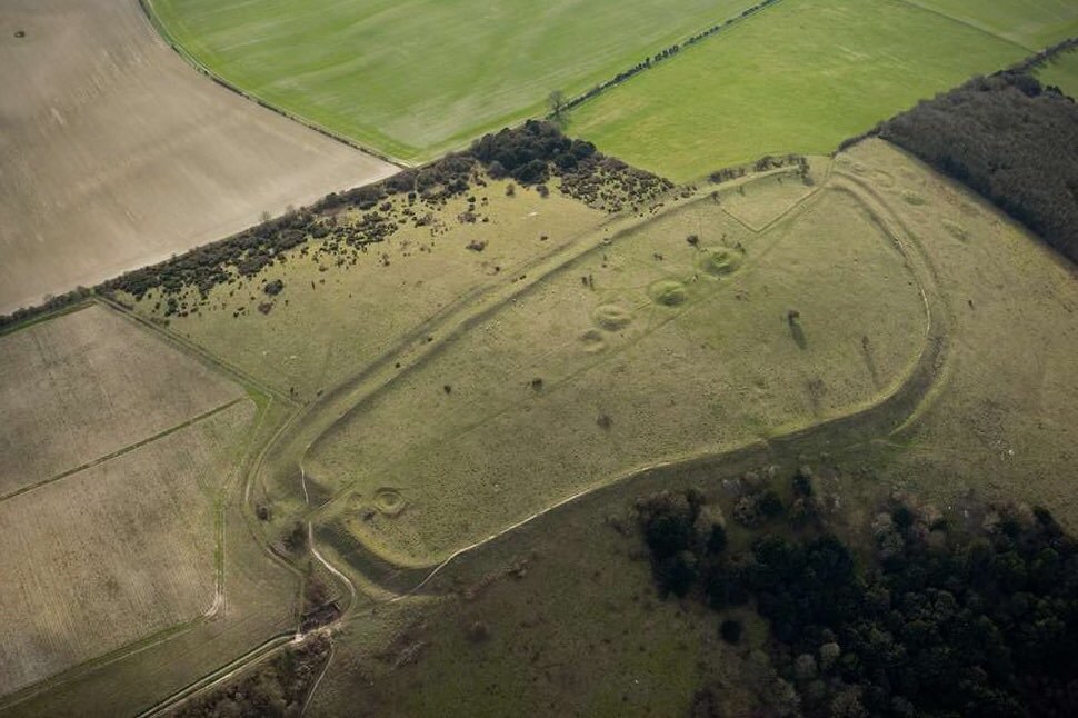
Old Winchester Hill is one of Hampshire’s great hill forts, situated on the southern chalk ridge of the county like the other fortifications of Danebury and St. Catherine’s Hill. The hillfort has never been fully excavated but was probably built in the Early Iron Age c.550-400 BC and fell out of use around the beginning of the Late Iron Age c.150-100 BC.

The defences of the hillfort completely enclose the spur, forming a roughly east-west aligned sub-trapezoidal interior area of about 4Ha. the main fortifications is a univallate rampart comprising a high single bank, rising in some places to some twenty-three feet above the ditch.

The ramparts are most substantial adjacent to the two original entrances at the south east and west ends of the hillfort where they rise to about 3m above the interior and up to 10m above an exterior ditch and counterscarp bank. The ramparts are inturned at both entrances. The south east entrance survives as a 7m wide gap through the ramparts, flanked on the northern side by a low flint wall and strengthened by an external hornwork.

The forts location is very important, as it is strategically placed east of the River Meon, and its inhabitants would have found it easy to watch for invaders coming along the river valley. It has been suggested that it may have been the tribal centre of the regions of the Meon Valley.

Neolithic/Bronze Age
Within the hill fort can also be found several Bronze Age bowl barrows and a postulated pond barrow dating from between 4500 and 3500 BC. The barrows are aligned in three groups – east-west along the central spine of the spur, north-south to the west of the hillfort and east-west along the false crest of the hill. These reflect the earlier use of the monument as represented by a suggested earthwork enclosure indicated by the infilled remains of a ditch across the interior of the hillfort at the eastern end.
A Neolithic oval or long barrow and a Bronze Age round barrow cemetery lie as a group outside the hillfort abutting and partly underlying the western ramparts. All are below the crest of a slight slope. The Neolithic barrow is the northernmost of the group. It comprises a pear-shaped mound

All of these burials from the Neolithic through the Bronze Age all suggest that this hill has held some significance for many millenia. The fact that Mesolithic and Neolithic flint works have been recorded immediately east of the monument, also enhances the hills commercial importance.

In Walks Through History – Part 4 we pay a visit to one of the best preserved sections of Roman road in the country and take a look at a Bronze Age earthwork and the site of a Neolithic Causewayed Enclosure.
![]()


