
The Windmill Trail takes walkers on a circular route through open countryside and takes in Halnaker Hill. The route visits several points of historical interest covering 500,000 years of habitation. The signed trail starts opposite the northern end of the village hall car park.

Start: Boxgrove Village Hall Car Park SU 90679 07655
Finish: Boxgrove Village Hall Car Park SU 90679 07655
Distance: 4.5 miles
Ascent: 370 feet
Duration: 1h 40m
OS Map Required: OL10 Arundel & Pulborough
This is a new trail, established in 2020 by the Boxgrove Parish Council, in association with West Sussex County Council. It allows for a relaxed and scenic walk to the iconic Halnaker Windmill passing through Palaeolithic, Neolithic, Roman, Medieval and WW2 landscapes.

The route starts in the picturesque village of Boxgrove and heads east picking up Mill Lane. The hollow way track is part of the Roman road Stane Street which ran from London to Chichester.

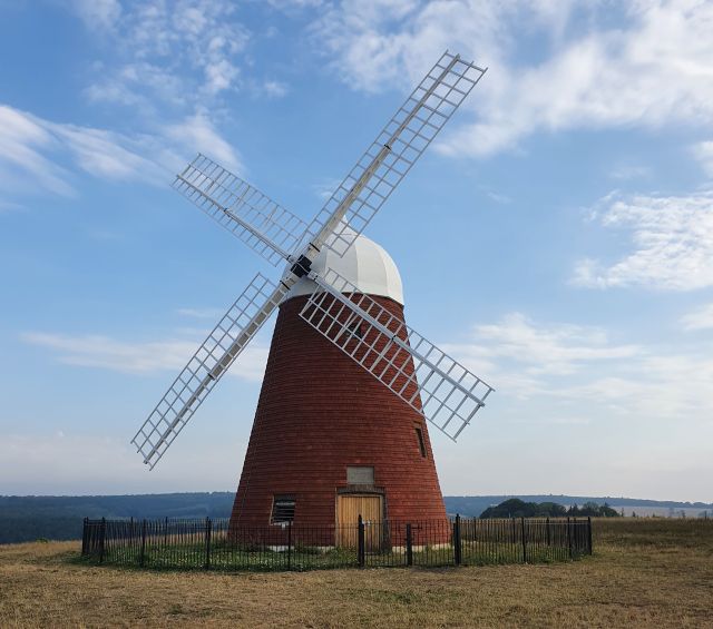
As the path approaches the top of the hill the skyline is dominated by the Windmill. The original mill was built by the Duke of Richmond in 1540 as the feudal mill for the Goodwood Estate. The current windmill was built between 1740 and 1780 and finally went out of use in 1905 following a lightning strike.
However, surrounding the top of the hill can be seen a faint ditch and bank which forms the Neolithic Causewayed Enclosure (3000-25000BC). What the purpose of the enclosure was is very much open to speculation by Archaeologists though it is agreed that it served a communal purpose.

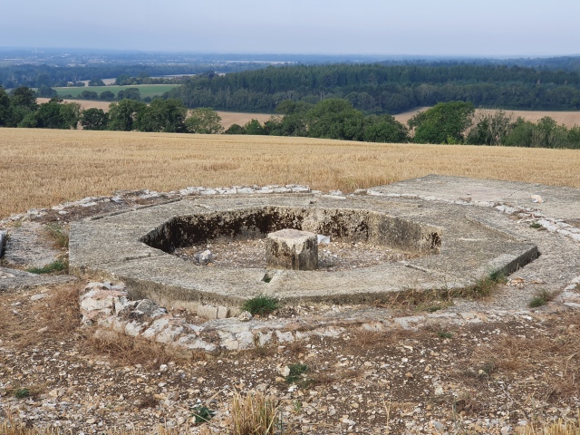
The more recent additions to the site are the World War 2 Direction Finding (DF) sites. All would have originally been surrounded by brick walls though only two appear to be intact. The DF was used to track, identify enemy aircraft, and direct our own fighter aircraft onto them.
Walking back down the hill the view to the south is very impressive with views out to the coast. However, 500,000 years ago the scene would have been very different. We would have been a lot further south, almost tropical, and we would be looking at a watery expanse with Palaeolithic hunter gathers roaming the countryside.

In a gravel quarry at the base of Halnaker Hill, two pieces of the tibia (shinbone) and two teeth were found which are thought to belong to Homo heidelbergensis or Boxgrove Man. This man or woman, dates to 500,000, is thought to be about 40 years old, 5 foot 11 inches tall, and weighed approximately 14 stone. This is the oldest Hominid discovered in Britain.
The final leg of the walk visits the Benedictine Boxgrove Priory. Founded on the site of an Anglo-Saxon church by the Abbey of Lessay in Normandy, some of the original Priory church remains along with additions dating through to 1532. Unusually, the domestic and cloistral part of the church is on the north side rather than the usual south side.

Following the dissolution of the monasteries by Henry VIII in 1536 the church continued as the Parish church but very little else survived. However, there are still substantial remains of the Priories Guest House, suggesting that this went into secular use after the dissolution.
This is a fantastic little walk with an awful lot to see. Car parking is free but having finished the walk by 09:30AM the car park was very nearly full, so it appears to be a very popular location.
Download a Leaflet about the Trail (pdf)
![]()
Ordnance Survey Maps Required


