
I had not planned to do another ‘Walk Through History’ quite so soon. However, I recently went on a walk to what I assumed was ‘just another Iron Age Hilltop Enclosure’. But when I got there the landscape did not seem right for ‘just’ an Iron Age enclosure. The landscape Archaeology was telling me something else!
On further investigation I discovered that the walk I had taken had archaeology dating back to the Palaeolithic Age through the Neolithic Age, Bronze Age, Iron Age, Roman Period to the Anglo Saxon’s. A time span covering approximately 500,000 BCE to 1066 AD.
As a result of this another walk was planned to the area to try to encompass as much of the visual Archaeology as possible.
The Trundle – St Roche’s Hill

Walk Details
Start: Seven Ways Car Park SU 87165 10993
Finish: Seven Ways Car Park SU 87165 10993
Distance: 3.2 miles with detour to explore the hill-top enclosure thoroughly
Ascent: 504 feet
Duration: 1hr 20min
OS Map Required: OL8 Chichester
Archaeology
Paleolithic Age 30,000 BCE – 10,000 BCE
Prior to the last Ice Age the coastline of this area came up to the southern base of St Roche’s Hill. However, as a result of the heavy ice sheets pushing down northern Britain, the south rose leaving the original beaches several miles inland.
This original coastline was frequented by Paleolithic Man and flint tools dating to the Paleolithic have been found at the base of St Roche’s Hill. The tools found were mostly hand axes (Roe & Holden 1968 p.211). Just to the southeast of the hill, at Boxgrove, a human bone 500,000 years old was found.
Neolithic Age 4000 BCE – 2,500 BCE
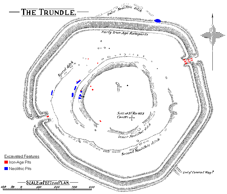
Within the confines of the Iron Age ramparts can be found at least two circular ditches forming a Neolithic Causewayed Enclosure. It can be clearly seen on aerial photographs and on the ground in the form of shallow depressions. The enclosure itself is large by Sussex standards, only equalled by Whitehawk enclosure.
Part of one of the ditches was excavated by Curwen (Curwen 1929,1931) and contained mostly worked flint, animal bones and Neolithic pottery of the ‘Windmill Hill’ type suggesting a cultural connection to this Causewayed Enclosure site near Avebury, Wiltshire, along with several other artifacts.

Bronze Age 2,500 BCE – 700 BCE
Unfortunately, very little remains of the Bronze Age on the top of the hill itself. Land snail evidence suggests no settlement from the end of the Causewayed Enclosure to the arrival of the Iron Age (Bedwin & Aldsworth 1981 p.209).
However, the Royal Commission on Historic Monuments England (RCHME) suggests evidence for a Bronze Age round barrow with a surrounding ditch, close to where the current day OS Trig Pillar stands. They also suggest the ‘Covered Way’ which points towards the barrow from the South-East is contemporary with it, as the Iron Age ramparts cut across it and so post-dates it.
To the left of the final section of road leading up to the hill from Singleton can clearly be seen a ditch and double bank feature. This is one of two linear earthworks on spurs to the north of the hillfort. It has been suggested that these cross-dykes were constructed to control livestock in a nearby Bronze Age settlement.

Iron Age 700 BCE – 43 AD
The Trundle is the name given to the Iron Age Enclosure/Hillfort on top of St. Roche’s Hill. It dates from the Middle Iron Age around 250 BCE and is one of only four built in Sussex during this period. The ramparts enclosure 5.66 hectares and has entrances to the ENE and WSW.
The rampart is on average 1.8 metres high and was built in a series of nine straight sections. A few small excavations have been carried out on the site and have uncovered La Tene Pottery found in the ENE entrance and from elsewhere an assortment of Middle Iron Age pottery, cooking vessels, human and animal bones as well as iron objects including a knife, spearhead and an adze blade.
The enclosure was probably occupied by the Regni tribe before they moved south to a location that is now Chichester just prior to the Romans arriving.

Roman Period 43 AD – 410 BCE
According to a survey by the RCHME several possible hut platforms have been identified which may date to the Romano-British period. A few pieces of Romano-British pottery have also been found. This would suggest that there was some occupation on the hilltop during the Roman Period though not as extensive as during the Iron-Age.
Just to the west of The Trundle is the remains of a Roman road which linked Chichester with Silchester. Very little remains of this road, though traces can be seen in crop marks.
Anglo-Saxon Period 410 AD – 1066 AD
Whilst there is no trace on the hill, the villages of Singleton and West Dean have their origins in the Anglo-Saxon period.
Modern Day 2019 AD
The views from the top of The Trundle are amazing, and it is clear to see why the Iron Age people built this hilltop enclosure here. Access it relatively easy, even if you did not want a long walk. The Car Park is just below the summit so you could just visit the hill-top and leave the rest to others.
Either way, get up there and have a good look around, get some fresh air and reset your mind. While you are there, walk to the eastern edge of the enclosure and look down. Below you is the magnificent, and famous, Goodwood Race Course.


Map extract courtesy of Ordnance Survey![]()

Pingback: The Trundle: A Nerdy Day Out in Sussex – Libby Morris | Little Plover